Carlisle Bay Marine Park serves as the premier nautical gateway to the Parish of St. Michael, geographically positioned on the southwestern edge of Bridgetown. Reaching the park’s six shipwrecks and expansive white sands is a logistical priority for the thousands of visitors arriving annually via the Grantley Adams International Airport and the Bridgetown Cruise Port. Due to its status as a protected marine area and a UNESCO World Heritage buffer zone, the infrastructure surrounding the bay is highly regulated, offering multiple reliable transit modalities ranging from government-sanctioned taxi systems to historic pedestrian routes.
The Three Primary Modes
- Private Taxi: Fast, fixed-rate, and door-to-door service available from all major arrival hubs.
- Public Bus/ZR: The budget-friendly, local way to travel using the Fairchild Street or Princess Alice terminals.
- Pedestrian: A 20-30 minute walk for cruise passengers via the Princess Alice Highway and the historic Careenage.
Arrival via Grantley Adams International Airport (GAIA)
For international travellers landing at the Grantley Adams International Airport (BGI/GAIA), the Marine Park is located approximately 13 to 15 kilometres to the west. Under standard traffic conditions, the transit time ranges between 30 and 45 minutes. The route primarily follows Highway 7, the island’s main southern artery, which provides a direct trajectory through the coastal parishes of Christ Church and St. Michael before terminating near the northern boundary of the park.
Visitors should be aware of the “The Transit Window.” While the drive is typically efficient, Highway 7 experiences significant congestion during the morning rush (07:30 – 09:00) and the afternoon peak (15:30 – 17:00). If your arrival coincides with these periods, allow for an additional 20 minutes of travel time, particularly when navigating the areas surrounding the Historic Garrison.
The Fixed-Rate Airport Taxi System
Barbados maintains a highly regulated transport environment at the airport. Taxis operate on a government-mandated fixed-rate system rather than using meters. Upon exiting the arrivals hall, travellers must proceed to the official taxi stall to receive a fare ticket. This ticket prevents price gouging and ensures transparency. While the island does not host Uber or Lyft, the “pickUP Barbados” mobile application serves as a digital alternative for booking licensed taxis and facilitates credit card payments, though cash remains the standard for street-hailed vehicles. For more on local currency, see our Guide to Bajan Currency.
| Destination | Fare (BBD) | Fare (USD) | Capacity |
|---|---|---|---|
| Bay Street / Carlisle Bay (North) | $76.00 | $38.00 | 1-4 Passengers |
| Pebbles Beach / Marine Park (South) | $74.00 | $37.00 | 1-4 Passengers |
| Bridgetown Cruise Terminal | $92.00 | $46.00 | 1-4 Passengers |
The Cruise Passenger’s Journey: Exiting Bridgetown Port
The Carlisle Bay Marine Park is the most reachable world-class snorkelling destination for those arriving by sea. Whether disembarking from a Carnival vessel or another major line at the Bridgetown Cruise Terminal, passengers are located approximately 2 kilometres from the start of the park. Most visitors opting for efficiency take a taxi from the port’s internal rank; these usually cost between $5.00 and $10.00 USD per person for a shared van. This rapid transit ensures ample time to explore the bay’s six shipwrecks, including the purpose-sunk Ce-Trek which rests at a 12-metre depth to support the local marine programme. Always remain within the designated safety buoys. However, for those seeking a more immersive experience from the harbour, a scenic pedestrian route is available.
The Scenic Pedestrian Route
The walk from the terminal to the bay takes approximately 20 to 30 minutes. Upon exiting the secure port gates, turn right onto the Princess Alice Highway. To avoid the heat of the main road, look for the “seaside walkway,” a shaded, tree-lined path that runs parallel to the highway for the first half of the journey. This path offers immediate views of the Caribbean Sea and the industrial harbour activities.
Landmarks Along the Way
- Pelican Craft Centre: A hub for local artisans and the first major complex you will pass.
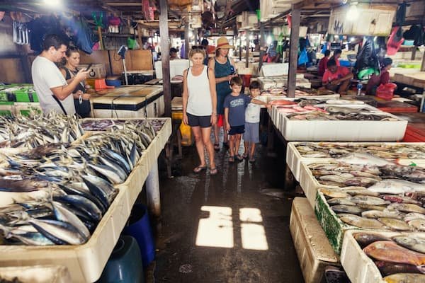
- Bridgetown Fish Market: A high-activity zone where the day’s catch, primarily Flying Fish, is processed.
- Hincks Street and Wharf Road: The transition into the historic commercial district, featuring colonial architecture.
The final approach requires crossing the Chamberlain Bridge, the gateway to the Careenage (the historic inner harbour). This bridge marks the start of Bay Street and the northern boundary of the Marine Park. From here, the first accessible beach is Brownes Beach, a short 5-minute walk from the bridge. For those interested in the culinary offerings immediately upon arrival, several beach bars and kiosks are located just past the bridge.
Navigating the Barbados Bus System
Public transport is a highly efficient way to reach Carlisle Bay from other parts of the island, such as Brighton Beach or the West Coast. There are three types of vehicles: large blue government buses, yellow privately-owned buses, and white ZR vans. All charge a flat fare of $3.50 BBD ($1.75 USD). For a full breakdown of how to identify these, refer to our post on Understanding the Barbados Bus System.
- South Coast Arrivals: Buses from the south and the airport terminate at the Fairchild Street Terminal, which is a 5-minute walk from the bay’s northern end.
- West/North Coast Arrivals: Buses from Holetown or Speightstown arrive at the Princess Alice Terminal. From there, you can take the #51 Bridgetown Shuttle to cross the city or simply walk 10 minutes southward.
- The “Sol Gas Station” Stop: For those wishing to access the central part of the park near the beach clubs, request the “Bay Street by Sol Gas Station” stop. This is served by routes 12A, 12F, 13, and 33.
Local Tip: If arriving by private vessel or authorized tour boat, use the Cavans Lane Public Jetty near the Careenage. It provides the only official docking and pedestrian access points directly into the northern section of the park.
Recommended Experiences & Transfers
Transit Frequently Asked Questions
Is there parking available if I rent a car to visit Carlisle Bay?
Public parking is available in designated lots near Pebbles Beach and behind the various beach clubs along Bay Street. While these spots are free, they tend to fill up rapidly by 10:00 AM on weekends and days when multiple cruise ships are in port.
What is the best way to ensure I return to my cruise ship on time?
Taxis are stationed permanently outside major beach clubs like Copacabana and The Boatyard. A return trip to the terminal typically takes only 10 to 12 minutes, but you should depart the beach at least 60 minutes before your “all aboard” time to account for city traffic.
Can I take a local bus directly from the airport with luggage?
Large blue government buses allow for some luggage if space permits, but the smaller yellow buses and ZR vans are often too crowded for large suitcases. If you have more than a carry-on, the regulated airport taxi system is the significantly more practical choice for safety and comfort.
How far is the walk from the city centre to the Marine Park?
The northern boundary of the park at Brownes Beach is located approximately 400 metres from the Chamberlain Bridge in central Bridgetown. It is a level, paved walk that is easily navigable for most visitors, including those with limited mobility.
Are the walking routes safe for tourists?
The pedestrian path from the cruise port through the Princess Alice Highway and Bridgetown is generally very safe and well-traversed by locals and visitors alike. However, it is advisable to stick to the main waterfront roads and avoid carrying large amounts of conspicuous valuables, as detailed in our Tourist Safety Guide.